
So I’m stopping for lunch near a trailhead at Sanborn Skyline County Park that happens to be across the road from Castle Rock State Park. The Sanborn Skyline parking lot is full, but none of those carloads of hikers are in the county park: they’re all over at the state park, which sorta reveals something about human nature: a state park must be better than a county park, right? True most of the time, but Sanborn Skyline is so much like Castle Rock that it’s a standing lesson about the limits of generalizations.
Among the similarities:
- Cool rocks: The tafoni formations — sandstone carved with tons of interesting caverns large and small — that everybody loves at Castle Rock are just as prevalent at Sanborn Skyline. The Indian Rocks formation near the trailhead across from the state park is worth a look and the Summit Rock formations offers an excellent overlook (though, regrettably, it is decorated by local youthful ruffians).
- Cool trees: Sanborn has several stands of the bark-shedding madrone trees that I’m so fond of. And you can pass through then without the serenade of nearby gun enthusiasts taking target practice (though I would note that gun owners making sure they can shoot straight is a good thing, nerve-rattling noise notwithstanding.)
- Cool camping: Sanborn Skyline’s walk-in campground is built into a hillside with a very steep path that wards off all but the hardiest campers, which means light weekend crowds even during the summer. Also nice and shady.
One way they’re not similar: Sanborn Skyline’s trails are far less crowded. Castle Rock still has one of the Bay Area’s signature hikes — the stretch of Saratoga Gap Trail tracking the ridge below Goat Rock — but if you’d like to hike Castle Rock minus the hikers, there’s an option right across the road on Skyline Boulevard.
OK, so let’s take a look at Saturday’s wanderings:
I had Melissa drop me off at the park headquarters and pick me up at Saratoga Gap, the intersection of Highways 9 and 35 where all the bikers congregate on weekends. I took the Sanborn Trail all the way to the Skyline Trail, did a side trip on the Summit Rock Trail, stopped by Summit Rock to take some pictures and headed over to the Gap for my ride home. This route is roughly eight miles with a bit over 1,000 feet of elevation gain. You can get a vigorous 12-miler in by starting at the HQ, hiking up to Skyline and doing the Summit loop and heading back on the San Andreas Trail.
Summit Rock is best avoided, despite the excellent view. It’s covered with graffiti, going there takes you within earshot of the gun club across the road, and getting up on it to take in the view is a tricky proposition for inexperienced climbers (and cowards like yours truly). The two miles over to Saratoga Gap from there are nothing to write home about either. You’re best off starting at the park HQ ($6 to park, alas) and fashioning a loop between the Sanborn and San Adreas trails, and heading up to Skyline if you need some extra miles.
Let’s see some pictures:
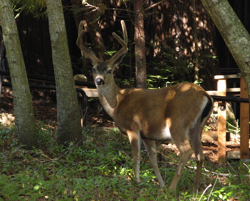
Before I stepped foot in the park, I noticed a pair of young deer bucks wandering through. As I walked toward the park visitors’ center I noticed they were still hanging around. You can tell it’s early in the season because their antlers still have the fuzz on them.

The Sanborn Trail starts out paved from just left of the park visitors center. It heads up through the walk-in campgrounds — straight up the hillside; gets you warmed up in a hurry. Though this way will induce some heavy breathing on the way up, it’s much preferable to go up this way and come back down on the San Andreas Trail, which has a lot more switchbacks and is a more comfortable descent. Also, the trail junction at San Andreas and Sanborn is easier to find going this way; I walked right past it coming down from Skyline last week.
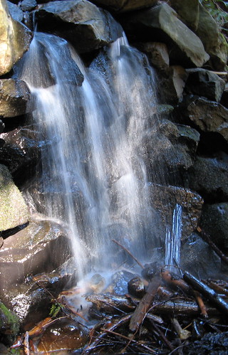
This is the same waterfall I tried to shoot last week under direct noontime sun. Had better luck in the early morning this time. The Sanborn Trail flattens for awhile here before marching up the hillside in earnest. The trail stewards must’ve had a spare-the-switchbacks-spoil-the-hiker outlook in life when they built this one. It’s not brutal — and, after all, it’s all in the shade — but it’s about a thousand feet of climb in less than two miles, so it’ll get your heart going.

Some nifty holes in a chunk of sandstone along the way.
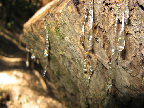
Sap drips from a recently cut tree.
Sanborn Trail, near the San Andreas Trail junction.

One reason to check out the Skyline Trail: it always seems to have cool wildflowers. Looks like this one is going to seed.
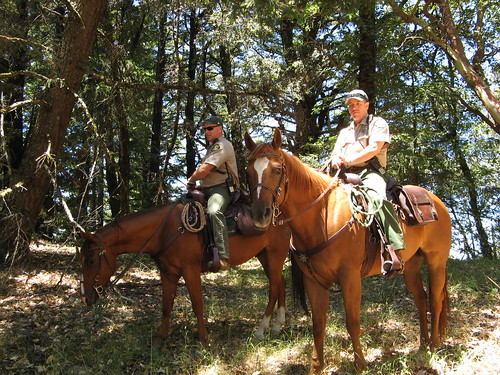
A couple park rangers with the Santa Clara County Parks Department’s Mounted Patrol. They were hanging around near Summit Rock, hoping to discourage hooligans from further trashing the area.

I had to tiptoe along an easy section of Summit Rock to find this overlook — getting up is doable but getting down is the hard part. Thing is, there are tons of nice valley overlooks, it’s not worth risking a broken neck here to see something I’ve seen a zillion times before.
So those are the Sanborn Skyline highlights; there will be a writeup on this park in my column at the paper in a few weeks.
More Sanborn links:
Last week’s hike.
Santa Clara County Parks and Recreation Page.
Wikipedia entry
Shady Shakespeare Theatre Company.
Beautiful pictures! I haven’t seen a deer up close like that in a little while, but it’s always a great experience.
What is it about rangers or game wardens or horsepackerguys or cowboys that is just so HOT???? ;0) I can’t help it!