
Seeing the Linville Gorge from its heights a couple weeks back gave me a burning itch to check out its depths the next time around. One of the easiest ways to go deep is to find the Spence Trail on the east side of the gorge on Table Rock Road. The trail descends relatively gently to floor of the gorge, where a footbridge crosses the Linville River and more explorations await on the Linville River Trail.
I figured taking the sane, reliable route would drain all the drama from this week’s update, so I found a nearby unofficial trail from the good folks at Linvillegorge.net, uploaded one of their tracks to my GPS unit, and charged forth into the forest.
What happened next demonstrated beyond doubt that the proper response to a burning itch is to consult a medical professional. I’ll stop short of saying “don’t go this way if you’ve got a lick of sense,” but I will say you’d better damn sure know your way around a topo map and compass. The longer I was out there, the louder the voices in my head were screaming, “dude, you are toast if you drop your GPS unit down a crack.”
I started out on the southeast side of Hawksbill Mountain on a faint rumor of footpath called Ledge Trail. It’s barely visible from the road, though not impossible to find. It’s just south of a gravel road that looks like it goes down to a campsite. It’s wild and overgrown, but reasonably easy to follow if you pay attention.
The fun started on the next section: a cut-off trail that tracks over to Spence Trail. This section might best be called “GPS-only” — parts of it are visible for extended stretches, but other parts fade into the hillside, or get obscured by large rock formations.
As long as you stay on track, you eventually intersect with the Spence Trail; from there the hiking is almost comically easy in comparison.
Let’s see some pix:
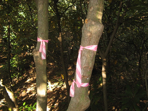
These two trail ribbons mark the turn-off to the Ledge Trail connector, which runs over to the Spence Trail. Ribbons like these mark a few of the key turns. You wish there were more but then you remember, “moron, this is Designated Wilderness; you’re lucky somebody left these.” There’s one point down the trail where a pink marker seems to clearly mark a leftward turn in the trail; perhaps 20 feet down the trail, another tiny red ribbon marks another left turn; took me about 15 minutes to find that turn, even with my GPS.
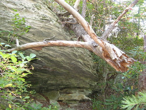
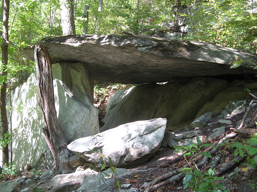
These rock overhangs never fail to impress me.
So after scratching and clawing my way over to the Spence Trail, I headed downhill to the Foot Bridge crossing the Linville River. The closer you get, the louder the Linville River roars down the canyon. The bridge crossing is all you need to see why people keep coming back here, crazy trails and all.
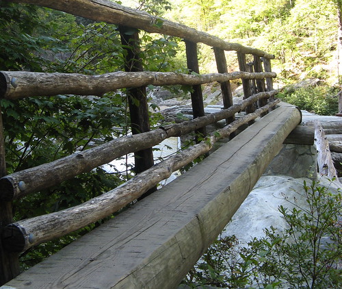
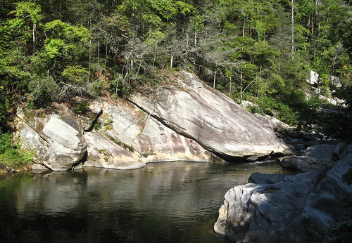
The river pools in many places near the Foot Bridge; just hanging out here and soaking up the view would be the perfect way to consume a few hours, but I wanted to head downstream, so I picked up the Linville River Trail just up from the opposite bank.
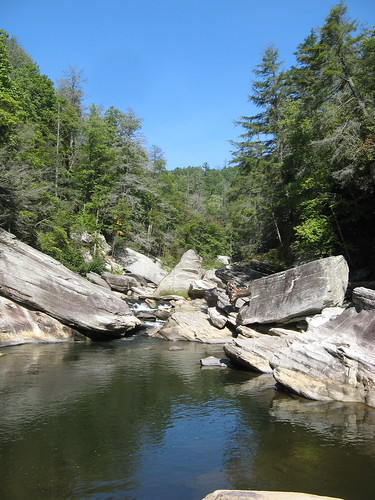
I hiked less than a mile south along the Linville River Trail; felt like I might’ve straggled into a suburb of Bedrock here.
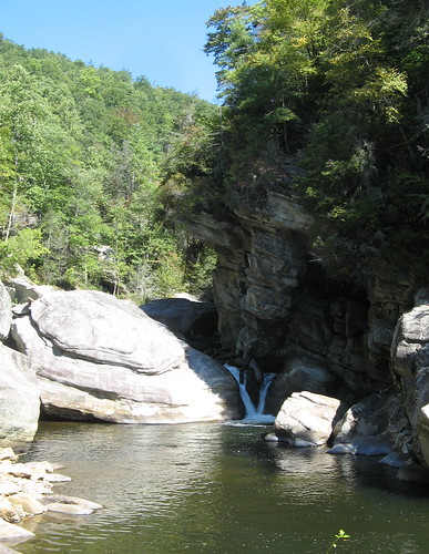
The great temptation of the Linville River Trail is deciding when to scramble down to the water’s edge. I found one opportune ravine and headed down to this small waterfall, had some lunch, and slogged back up the hillside.
I headed back the way I came and paused for another shot at the Foot Bridge over the river.
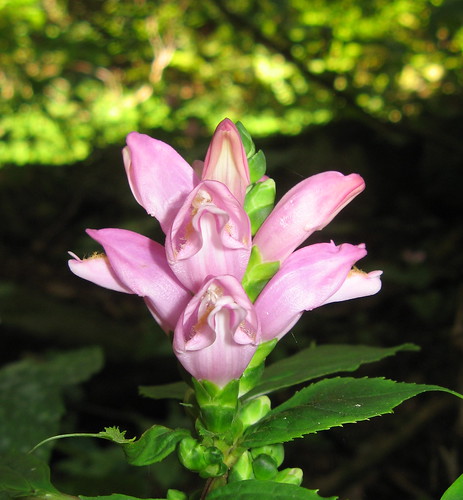
Saw these very interesting wildflowers along the way.
Also liked the way this shot came out looking vaguely like something Jackson Pollack might have painted.
Retracing my steps back up the connector trail, I realized something you can never forget in the Gorge: going up an almost invisible trail is an order of magnitude more strenuous than going down it. The connector trail is all uphill and requires navigating around a few huge boulders. By the time I got back to the Ledge Trail, I was just about spent, physically and mentally. This ones one of the rare times I just wanted this hike to be over.
Reading my gripes might seen like reason enough to confine your travels to the officially designated trails, which are ragged enough, but remember there are only 18 official trails in Linville Gorge Wilderness, vs. more than 80 documented by the hardy travelers at Linvillegorge.net. You can’t be faulted for wanted to stray beyond the trails the Forest Service approves of.
Just make sure you bring extra batteries, and you actually know how to navigate with a GPS unit. And have a fallback plan for when your gadget falls down a crack (I’ve found that preparing for the worst is the best way to keep it from happening).
Links for this hike:
- Everytrail GPS tracks
- Last week’s Hawksbill Mountain hike.
- Linvillegorge.net
- Linville Gorge fact sheet
Google map for this hike:
View Linville Gorge Wilderness, Ledge Trail to Spence Trail in a larger map
You made me want to buy a real GPS unit instead of relying on my phone. I hope you had is strapped onto your belt or pants just in case it slipped out of your hands. Something like a Nikon camera strap would probably work.
Makes me want to get out my hiking gear and plan a fall hiking expedition.
This continues to be my favorite hiking blog. Between the mysteriously near getting lost in the woods, gripping writing and the Jason Pollack reference (good call on that), that was quite a good read!
Nice pictures! Those wildflowers are gorgeous-I’m curious as to what they are. I love being off the beaten path, I live for those experiences. In response to David, I just recently bought the Magellan ToughCase for my iPhone, which he may find useful if he has an iPhone. Check out the review:
http://redtailtrails.com/gear/magellan-gps-toughcase-for-iphone
Missed you by only a day in Linville Gorge. We were hiking the MST along the eastern edge on Sunday and Monday. The Wilderness is nothing to mess around with. We missed a turn and got off on a side trail. It took map reading, GPS, altimeter and compass consulting, head scratching and intuition to get us back on track. We knew how to backtrack and we had plenty of daylight, but I was still a little bit nervous. As Lee Lewis, a Smokies Search & Rescue volunteer said, “You don’t want to take on Mother Nature (unprepared). She’ll spank you and send you back home every time.”
Nice photos! I have never gone hiking and in fact am terrified to even go far into my husband’s farm ‘jungle’. And the thought of getting lost- ugh!
Good accurate report. You might have wondered why this Spence -Ledge Connector (SLC) that you took even exists when it would be so much easier for a hiker to stay on Spence Ridge trail. Here’s why: Several years ago some folks wanted a trail that would go entirely around the Linville Gorge without traveling along a road. The SLC is a small segment in a 39 mile loop. A gif of that route is in Yahoogroups Linvillegorge FILES…scroll down to LG grand Loop2011. Youll have to join the yahoogroup to do this and you can see how SLC fits in to the entire loop. Most of the Grand Loop is not this rough. Try Ledge again and this time continue past SLC and push the Ledge trail up to almost the top of Hawks bill–a spectacular hike!