

I read awhile back that somebody said you might learn more from climbing the same mountain 50 times than you would from climbing 50 individual mountains. Hiking trails are much the same. I was on my morning hike the other…
I read awhile back that somebody said you might learn more from climbing the same mountain 50 times than you would from climbing 50 individual mountains. Hiking trails are much the same. I was on my morning hike the other…

I used to delude myself that going on hikes and encouraging others to do the same via my blog was the extent of my obligation to the planet that makes it all possible. The guiding philosophy of outdoor-oriented recreation is…

The winner of the Two-Heel Drive challenge to relate readers’ most extreme hiking experiences is one Thom Gabrukiewicz, who emerged bloodied but not bowed after a backpacking adventure in Northern California’s gorgeous Trinity Alps. Here’s the link to Thom’s original…

And now I can finally reveal the shocking truth behind the Tell Your Most Extreme Hiking Tale giveaway: it all started because somebody on the social media team for Pemmican Beef Jerky picked an opportune time to flatter my ego…

UPDATE: This contest expired Nov. 8, 2011 Extreme hiking stories inevitably boil down to: at which point did you decide to turn back? At the first sign of trouble — when it made sense — or after a string of…
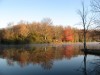
I love it when a plan doesn’t work out. Last week at Stone Mountain was only mildly colorful at 2,300 feet, so this week I surmised the woods would be blazing around 3,500. I woke at an absurdly early hour…
Score another one for the magnetic personality of Stone Mountain: I had just finished a fine loop hike of just under 6 miles on the Blackjack Ridge and Wolf Rock trails. I sat on the grass near the base of…

UPDATE: This contest expired Nov. 9, 2011 …. NOTE: I have picked the five finalists in this contest. Click the link to vote on your favorite (Nov. 8 is the last day you can vote). C’mon, dish: you’ve seen some…

“What did you guys do for fun when you weren’t working?” I ask the guy. “Any girls we could find!” Hoots and giggles fill the Bathhouse at Hanging Rock State Park, where one Dr. Harley Jolley is just about done…