
These hikes are featured in the Travel section of the San Jose Mercury News for Aug. 3, 2008.
Lassen Peak Trail
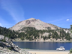 Where: Lassen Volcanic National Park
Why: Never climbed a real mountain? Here’s your chance: The 2.5-mile path to the top of Lassen Peak (actually a volcano that last erupted early in the 20th century) will give your heart a good workout and you’ll see some of the finest scenery in far northern California’s volcano country, including Mount Shasta far to the north
Details: Strenuous 5-mile out and back from 8,500 feet to 10,457-foot summit. Wear sunscreen, there’s no shade.
Driving: 4.5-5 hours, about 270 miles from San Jose
Getting there: Take I-680/880 north to I-80 north to I-5/505 to Exit 649 at Red Bluff. Take Antelope Boulevard to Highway 36, turn left, go 43 miles and turn left at Lassen Peak Highway and go about six miles to park entrance. Trail head is along the main road about six miles into the park. Get there via Google map.
Entrance fee: $10 for seven-day pass.
On the Web: www.nps.gov/lavo
Panorama Trail
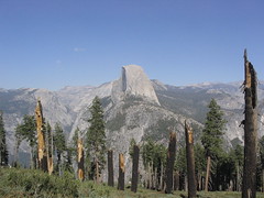
Where: Glacier Point, Yosemite National Park
Why: Yosemite’s celebrated Half Dome is your constant companion along this lovely walk through rocky, forested terrain. Hike 5.2 miles to Nevada Falls and return if you’re feeling strong; otherwise just go till you feel like turning back.
Details: Moderate 5- to 10-mile out-and-back above 7,000 feet; some tricky terrain. Stay on dry land, the waterways can lead to waterfalls — falling over one is fatal.
The drive: 4.5-5 hours, about 210 miles from San Jose.
Getting there: Take I-580 to I-5, and turn off at Highway 120 at Manteca. Stay on Highway 120 all the way to Yosemite Valley, From the valley, follow signs to Highway 41 South, turn right, go just over nine miles to Glacier Point Road, take it 15.7 miles to Glacier Point visitor center. Trail head is on the right side of the parking lot. Get there via Google map.
Entrance fee: $20 for a seven-day pass.
On the Web: www.yosemitefun.com
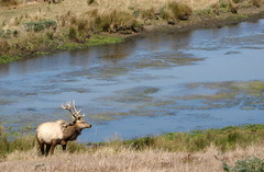
Tomales Point Trail
Where:
Point Reyes National Seashore
Why: Pacific breezes can make this a cool outing even on the hottest days of the year. Speaking of heat: Thule elk breeding season begins in late summer, so it’s a good time to check out the mighty bulls as they build their harems (from a safe distance; those antlers are very sharp).
Details: Moderate 5- to 10-mile out-and-back. Bring a windbreaker; never approach the thule elk.
Driving: 2.5 hours, about 100 miles from San Jose
Getting there: Take the scenic drive up Highway 1 from Highway 101 in Sausalito. Stay on Highway 1 until Point Reyes Station, then turn west on Sir Francis Drake Boulevard. Go six miles and turn right at Pierce Point Road, stay on it till the road ends in the parking lot at Pierce Point Ranch. The trail head is well marked at the parking lot. Get there via Google map.
Entrance fee: none.
On the Web: www.nps.gov/pore
Ohlone Bluff Trail
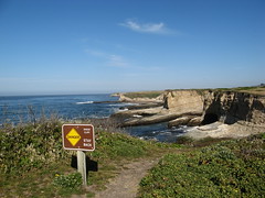
Where: Wilder Ranch State Park
Why: This trail has everything you need for a casual stroll: ocean breezes; crashing waves; wide, flat trails; California’s spectacular coastline. It’s one of the best hikes for beginners in this part of California.
Details: Easy 2-5 miles, mostly flat. Bring a windbreaker; avoid cliff edges.
Driving: One hour, about 30-40 miles from San Jose.
Getting there: Take Highway 17 south to the Highway 1 north exit in Santa Cruz. Take Highway 1 out of town and watch for the Wilder Ranch sign a couple of miles past the city limits. Turn left into the park. Get there via Google map.
Parking fee: $6.
On the Web: www.santacruzstateparks.org
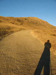
Mission Peak summit at sunset
Where: Mission Peak Regional Preserve
Why: Fremont’s signature peak bakes in the sun all summer, but there are two cool, captivating alternatives: late evening, when the hill turns golden in the fading light; or early morning, as the fog lifts. Though the park officially closes at sundown, intrepid hikers often can’t resist the temptation to catch a sunrise or sunset from the summit. If you dare, go under a full moon.
Details: Summit-and-back hike goes 5.6 miles with over 2,000 feet of climb. Bring a windbreaker and flashlight if you’re out near dark.
Driving: 20-30 minutes, about 10-15 miles from San Jose.
Getting there: Take Interstate 680 to southern Mission Boulevard exit; go east on Mission Boulevard for a half-mile; turn right at Stanford Avenue; and follow it to the park. Get there via Google map.
Parking: Free; lot is often full but you can park on a nearby side street. Never leave valuables in your car: The area is a favorite of smash-and-grabbers.
On the Web: www.ebparks.org/parks/mission
All of these are on my list except Mission Peak, that one I have done. The sunset was beautiful. Had a blast at the summit with my hiking pals who had even packed up wine and cheese.
I haven’t hiked the Panorama Trail, but I’ve always been told that it’s better to park in the valley take the free park shuttle to Glacier point and hike all the way down to Happy Valley. This would seem to make more sense than an out and back.
Gah! That should be Happy Isles, not “Happy Valley”
OK, now I’m really blowing it. The Glacier Point shuttle is not free. But the rest is right, really!
Carl: The nice thing about this out-and-back is you have the trail pretty much to yourself… if you go downhill past Nevada Falls and down to Happy Isles you’ll tiptoe through a thousand tourists (plus it’s eight miles, a non-trivial distance for many hikers).
I’d be willing to forgo the waterfalls and Mist Trail … mainly I was looking for a great hike that was out of the way and didn’t require driving another 40 miles to the high country (which, admittedly, is where all the great hiking is at Yosemite).
Hi Tom,
I hiked the Panorama from Glacier Point to Illilouette Falls back in May (http://jerrywcca.blogspot.com/2008/05/yosemite-glacier-point-and-illilouette.html) but didn’t make it to Nevada Falls. I had it all to myself once I got 500 feet past the visitor’s center. Only complaint was all uphill on the way back!
Oh, and Tomales Point is one of my favorites.
Jerry: I was there in September, after summer vacation was over for most kids, and I had a similar experience, crowd-wise. Probably a few more people at this time of year.