
From the San Jose Mercury News, October 2007
Wunderlich County Park seems close to everything, but if you stop by on a weekday you can still feel a thousand miles from civilization.
Acres: 942
Miles of trails: 15
Hours: 8 a.m. to dusk.
Limitations: No bikes, pets, camping or fires.
Parking: Free
Driving directions: Take the Woodside Road (Highway 84) exit from I-280, go west for three miles. Park will be on the right.
It’s a passable getaway on weekends, but the parking lot fills up quickly, a consequence of its shady, sanely graded trails and easy proximity to Interstate 280, Woodside and Portola Valley. Wunderlich is home to the historic Folger Stables and a working horse-jumping ring, so there’s a fair amount of horse traffic on the weekends, too.
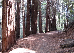
That’s why I’d urge stopping by on a weekday, when you’ll have the park’s trails through redwoods, Douglas fir, oak, madrone and eucalyptus to yourself. On your way up the hillside, as the sounds of traffic, airliners and construction sites fade, you’re bound to get that priceless sensation of playing hooky. And if you do get busted for sneaking away from the job, you can always tell the boss you’re reining in health insurance costs by taking vigorous walks in the woods.
Standard precautions: Keep an eye peeled for horse poop. You’ll have better luck finding a parking space on weekends if you avoid the 9-to-11 a.m. crush, when most folks start their hikes. Maps at the trail head are hard to read – much better ones are available online for $1 at www.virtualparks.org.
Hike suggestions:
Easy: Wunderlich is on a hillside, and all the trails require climbs, but the Bear Gulch Trail has the most switch-backs to ease the strain. An excellent 3.2-mile loop combines the Bear Gulch, Madrone and Redwood trails (if you can handle at least two miles, try to see some of the Madrone Trail, which has beautiful stands of young redwoods).
Moderate: The essential Wunderlich hike takes Bear Gulch Trail for 2.2 miles to the Meadows, where you can rest at a bench overlooking the Santa Cruz Mountains, then go another third of a mile to the Alambique Trail and return 2.4 miles to the parking lot.
Hard: Trek all the park’s best trails with this 11-miler: The first half is all uphill – Alambique Trail to the Crossroads, then up Skyline Trail to Skyline Boulevard. The second half is all down – return via the Alambique, then take Bear Gulch Trail to Redwood Flat, a side trip on the Redwood and Madrone trails, and the final return leg on Bear Gulch.