
From the San Jose Mercury News, November 2007
Mount Madonna County Park has the ruins of a pioneering California land baron and a herd of snow-white European deer that were the gift of a pioneering California press baron. It also has 118 shady campsites for folks still feeling a bit of that pioneering spirit.
Acres: 3,688
Miles of trails: 20
Hours: 8 a.m. to sunset
Dogs: OK if leashed
Parking: $6
Camping: 117 sites, $20-25 per night ($10 in off-season, November through February); to reserve, see gooutsideandplay.org
or call (408) 355-2201.
Driving directions: Take Highway 101 to Highway 152 West exit; go west for 10 miles to park entrance at Pole Line Road.
On the Web: www.parkhere.org.
Best Bay Area hikes
Best California hikes
Great place to visit, but would you want to hike there? Well, yeah.
The park, west of Gilroy at the southern crest of the Santa Cruz Mountains, has some of the nicest paths through second-growth redwoods in the region. Trails often pass in and out of redwood, oak woodland and manzanita scrub environments, sometimes within minutes of each other.
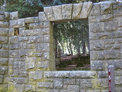
Mount Madonna’s centerpiece is the former weekend home of Henry Miller, a Gold Rush-era land-and-cattle millionaire who built an expansive mansion atop Mount Madonna. When he died in 1916, he owned more than 1 million acres. Fires and the ravages of time have left little beyond concrete footings and a few broken steps and stone walls where Miller took respite from his ranching empire.
Another highlight is a small herd of white fallow deer, descendants of a pair William Randolph Hearst gave to the descendants of Miller in 1932. They’re kept behind a fence to prevent them from going into the woods, where they’d likely become a nuisance.
Standard precautions: Watch for poison oak on narrow trails, and keep an eye out for equestrians. Also, summer camping at Mount Madonna can be downright chilly, as the Pacific Ocean marine layer settles over the campgrounds.
Hike suggestions
Easy: Check out the deer pen and the Henry Miller site, and take in the Upper and Lower Miller Trails, with less than a mile between them.
Moderate: Check your map, and build a loop out to the Tie Camp Trail. Any route there offers a sampling of the park’s memorable biodiversity in four to five miles. The Redwood and Iron Springs trails are especially nice.
Hard: Park free at the Sprig Lake Recreation Area on Highway 152 seven miles west of Highway 101 in Gilroy and take the steep – but gorgeous – Sprig Lake Trail up to the campgrounds. Find your way to the Miller site, and return via the Ridge Trail for an invigorating six- to seven-miler. Side trails abound, so it’s no stretch to plot a much longer trek.