
From the San Jose Mercury News, December 2007
A few hours at Mission Peak Regional Preserve might make you wonder if the United Nations has a West Coast hiking club.
Acres: 2,999
Miles of trails: 22.
Park hours: 7 a.m. to dusk
Parking: Free at Stanford Avenue; $2 at Ohlone College parking lot when class is in session.
Camping: Reservations required for the Eagle Spring Backpack Camp behind the peak. $5 per person per night plus $8 reservation fee. Ohlone Wilderness Trail permit required, $2 (including map), can be picked up at Sunol Wilderness or Del Valle Regional Park. Call (888) 327-2757.
Driving directions: For main trail head, take Interstate 680 to southern Mission Boulevard exit; go east on Mission Boulevard for a half-mile; turn right at Stanford Avenue; and follow it to the park. For Ohlone College access, take northern Mission Boulevard exit and turn southeast, continuing for three-quarters of a mile; turn into college; buy parking pass from vending machine in Lot B; park in lots M, N, O or P.
On the Web: www.ebparks.org.
Fremont’s signature peak attracts people from everywhere. I’ve chatted with hikers from India, China, Taiwan, Russia, Mexico and even remote, exotic places like Livermore.
You don’t come to Mission Peak expecting solitude: the parking lot’s like a shopping mall on weekends. You come to meet interesting people and to stand on the summit. There’s no easy (or even moderate) route to the top – it’s nearly 2,200 feet above the trail head – but the view up there is worth every step.
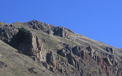
The view on the way up is pretty good: On clear winter days you can see all the way to San Francisco. The real payoff, though, is the first sight of the Diablo Range to the east, about one-third mile from the summit. It’s stunning after a winter storm leaves a dusting of snow on the distant peaks. The vibe is positively alpine, and with any luck you’ll meet a hiker from Switzerland who can compare notes.
Standard precautions: Keep your distance from grazing cattle. Dress for working up a sweat, and have a jacket to block the powerful winds at the top. Wear sunscreen; there’s no shade. Park legally – the citations are expensive. If you park on the street off Stanford Avenue, never leave valuables in your car; break-ins are common.
Hike suggestions
Hard: Hidden Valley Trail is the wide gravel path to the top from the park’s Stanford Avenue trail head to the summit. Footing’s tricky nearest the top. Total distance is 5.6 miles up and back.
Harder: From the summit, return on the Horse Heaven Trail for a loop of just under eight miles. The trail’s a bit hard to follow in places, but it’s the one spot where you can find solitude on the Fremont side of hill.
Hardest: The 12-mile out-and-back on the Ohlone Wilderness Trail from Sunol Regional Wilderness is the prettiest path to the peak. Ohlone Trail permit, $2, required. Go to the East Bay Regional Parks Web site at www.ebparks.org for more details on Sunol, where you can pick up the permit.