
From the San Jose Mercury News, April 2008
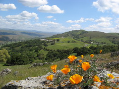
Pedal power meets petal power every spring at Santa Teresa County Park.
Park profile
Acres: 1,688
Miles of trails: 14-plus
Hours: 8 a.m.-dusk
Limitations: Dogs must be leashed.
Parking: $5 at Pueblo Day Use area; free at Stile Ranch trail head
Driving directions: To Pueblo Day Use area, take Highways 101 or 85 to Bernal Road exit; head west for about 2.7 miles; turn left into park entrance. To Stile Ranch, take Highway 101 to Bailey Road exit; go west for 3.2 miles to McKean Road; turn right (north) and go 2.8 miles to Fortini road; turn right and go 0.6 miles; turn left at the T, and the trail head will be on your right.
On the Web: www.parkhere.org
The park at San Jose’s southern edge is a magnet for mountain bikers who delight in molar-rattling rides along the rockier trails. Riders were out in force on a recent Sunday, perhaps hoping to get in some trail miles before throngs of flower-gawking hikers began stalking Santa Teresa’s sunny, open terrain.
The first poppies and bluedicks of the season are already blooming, and more color is sure to paint the hills in coming weeks. If you see bikers parking their rides and staring at the hillsides, you’ll know it’s the height of flower season.
Standard precautions: Bring sunscreen – there’s little shade (but lots of breezes). Be extra careful exploring those poppy-popping rocky areas: rattlesnakes hang out in the same terrain.
Hike suggestions
Easy: Stile Ranch Trail has the best wildflowers. It’s rocky, and it attracts many mountain bikers, but it’s only 1.5 nicely graded miles (one way), zigzagging up and over a hillside. It’s the one must-hike trail (though actually outside Santa Teresa’s borders).
Moderate: From Pueblo Day Use Area, take Mine Trail to the Rocky Ridge Trail to Coyote Peak Trail and the Coyote Peak summit for panoramic views of the South Bay. Rocky Ridge is another bikers’ fave that has a rich array of wildflowers. Return on Coyote Peak Trail, and stay on it for about 0.7 miles. Then turn left for a shady break on the Ridge Trail. And then head back for about four miles that sample most of the park’s flora.
Hard: Take any combination of routes that include the Stile Ranch and Rocky Ridge trails, continue to the Coyote Peak Summit, then traverse the park to its high points on the Bernal Hill Loop (on the side of Bernal Road). Then return to where you started, and you will have covered eight to 10 miles of invigorating, up-and-down hiking.