
So it’s Mother’s Day and how’s this for luck: My mom lives 2000 miles away so I’m free to spend the day on the trail.
The Diablo Range (official title of the hills east of San Jose) is still mostly green but summer’s coming on fast, so I felt like getting out in the nearby environs before the sun turns ’em yellow. I hadn’t been to Joseph D. Grant County Park in over a year so I figured what the heck, let’s check it out.

Grant Lake is the wettest part of the park. The rest of it is bone dry already, except for a couple creeks I crossed. I stopped by the parking lot next to the lake to grab a map; a quick check reminded me that I had never hiked the Washburn Trail, which parallels the northwest corner of the park. The map has only one word describing the trail: "steep." With a fresh night’s sleep and zero miles under your feet, "steep" practically screams "hike me first!"
That’s what I heard, anyway.
For those thinking of trying the Washburn Trail: The most direct route to the trailhead is a mile up the road, so right off the bat you’re walking on pavement; the road isn’t terribly heavily traveled (especially if you start out early in the morning) but you do need to keep an ear out for approaching cars, bicycles and lunatics on absurdly fast motorcycles.
At the trailhead, you turn right and walk down an old ranch road past an old barn; after awhile it goes downhill and crosses a creek. Then the fun begins.

Speaking of fun: here’s what happens when bunches of balloons get launched skyward. Birds try to use them as prophylactics and nature’s delicate balance is tossed a curve.
From here it’s up and up and up and up — about 1400 feet in around two miles. I’ve hiked worse, but it’s a nice little workout. After the first quarter mile it began to dawn on me that it was going to be one hot day of hiking if the first couple miles were working up this big of a sweat. I also realized I was going to need a water stop before the day was up. Good thing I brought my trusty water filter along.

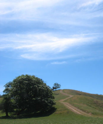
Note the incline of the ground below this tree. How long is this hill anyway?

I forgot to mention: there’ s almost zero shade along this trail.
The one consolation of huffing it up this hill: lots of wispy clouds make for pretty pictures. The trail tops out at about 2900 feet. At least there’s a breeze this far up.

Washburn Trail heads downhill for less than a mile and ends at this post; five miles of hiking so far, and a minimum of three and a half more to get back to the parking lot. But I didn’t come all this way to hike a mere 8.5 miles and go home — what would Mom think? I decided on a bigger loop that entailed turning right on the Canada De Pala Trail and following it for about three miles to the Twin Gates crossing at Mount Hamilton Road, then going another mile and a half to the Hotel Trail and another couple miles back to the Ranch House and back across Mount Hamilton Road and back to the lake and the parking lot, for about 11.5 miles. After the big hill at the beginning, the rest was fairly easy.
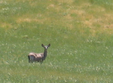
A deer watches me watching it.
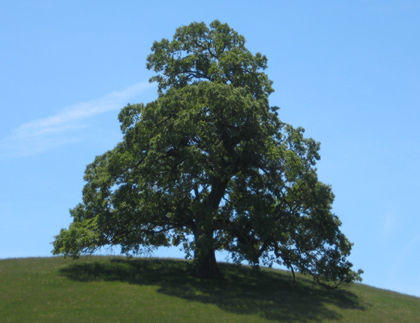
I’m sure I’ve seen this tree before at the park, but never from this angle.

Clouds do wavy things over Mount Hamilton, the highest hill in the distance.
Along about eight miles or so, it occurred to me that I probably didn’t have a three-mile supply of water.

Fortune smiled on me as I headed down a steep bit of trail and heard water running. I did some bushwhacking and pumped a couple fresh liters of creek water with my water purifier. Nice thing to have along on hot days when you don’t know how much water you’re going to need.

Another fine snag.

I was feeling pretty wilted too after about 10 miles of hiking in the sun.
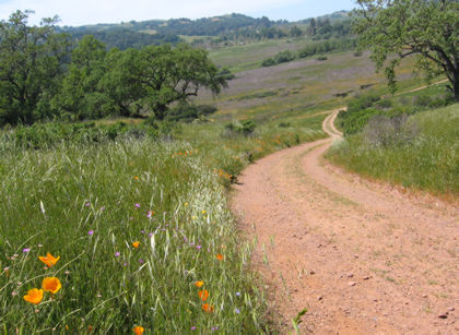
Poppies and other hardy wildflowers decorate a stretch of the Hotel Trail.

The Ranch House is where Joseph Grant — the son of a dry goods merchant who made it big supplying gear to gold miners — used to entertain guests. The hike’s about over now, just a quarter mile or so back to the parking lot across the road.
There’s a really killer loop hike that essentially tracks the parks borders for about 20 miles. I’ll hold that in reserve for a dry Sunday in February.