
With apologies to our beyond-the Bay-Area brethren, here’s the latest on our daring attempt to summit Mission Peak at sunrise on Thanksgiving morning.
Current weather forecast calls for sunny skies and an overnight low in the mid-40s. We’ll be donning layers and shedding them after about 10 minutes on the trail.
So far at least a half-dozen intreped trekkers have indicated an interest in coming along. Whether they show up depends on prevailing sanity trends.
The plan is to leave the Mission Peak trailhead at Stanford Avenue at 5:30 sharp so we can be at the top for the 6:55 sunrise. Sleepwalkers will be nudged in the proper direction; we know how shocking waking them can be. If you decide to come but arrive late, just start up the trail — you shouldn’t have trouble catching up, given that at least one of us will be hauling sixteen tons of cameras, lenses and polarizing filters (prime culprits in our political climate, I’m certain).
Those of us in the South Bay Hiking Elite know how to get to Mission Peak; to join the elite, come on along. How to get there:
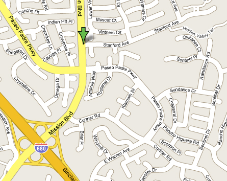
Here’s a Google Maps link to the Stanford Avenue turnoff which leads to the Mission Peak Regional Preserve. You take I-680 to the southernmost Mission Peak exit and head northeast to the second stop light, then go east on Stanford Avenue till you hit the Mission Peak parking lot. If it’s full, turn back and park along the street. Obey the No Parking signs; scofflaws get smacked with pricey parking tickets.
I’d like to keep this as informal as possible. If you want to come along, come along. Just keep in mind that if you miss the 5:30 launch you might be hiking uphill alone in the dark; which, considering the company, might be preferable. In any case, as Annie says, the sun’ll come up.
Mission Peak is an arduous two and a half miles to the top, but the view up there will definitely put you in “what I’m thankful for” mode.
2.5 miles and 2,100′ elevation gain works out to the equivalent effort of over 6 miles on flat land. But that won’t be the greatest challenge for me. The challenge for me will be getting anywhere by 5:30AM.
How about if I come by your house and set off all the car alarms in the neighborhood?