
Alum Rock Park, on San Jose’s southeastern edge, is about as fine a hiking park as you’ll find within the city limits of a town with a million people living in it. Most city parks have little need for trail maps, but most are not tucked into a steep-walled canyon like Alum Rock is. This is one place where a shaded-relief map with elevation lines comes in handy. Well, San Jose finally has one, now posted on the city’s park’s department’s Web site. The PDF is a huge file, over 17mb, so be warned before you try to download it.
Here’s a popular loop at Alum Rock that I sliced from the new map (I added the red track).
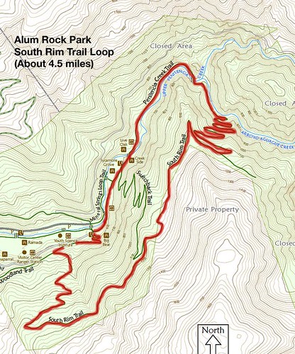
I’m pretty sure this is about 4.5 miles with about 600 feet of elevation gain. Click on the map for a higher-res version. Alum Rock can get noisy and crowded along park’s bottomlands, but I’ve never felt crowded on the South Rim Trail. The switchbacks up to the ridge ease the suffering on the way up.
Alum Rock links
- Alum Rock Park Profile, originally published in the San Jose Mercury News.
- My previous Alum Rock hikes.
- Flickr slide show of my Alum Rock pictures.
- City of San Jose’s Alum Rock page.
- History of Alum Rock Park.
Here’s a Google map to get you there:
View Alum Rock parking lot in a larger map