
Armor for your iPod
OtterBox Armor Series case at backcountry.com
AccuTerra terrain maps for hikers, bikers, campers and outdoor travelers are coming soon to the iPhone (the big Version 3.0 upgrade is June 17). Free “lite” versions of the software already are available and just happen to cover the San Francisco Bay Area and Yosemite National Park. They’re cool because they upload the maps into your iPhone so you don’t need an Internet connection — just an iPhone 3G with the GPS function turned on. If it can pick up a GPS signal, it’ll tell you right where you are.
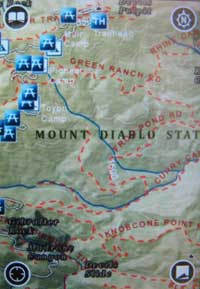
The pic at right shows a section of Mount Diablo State Park. Note the picnic tables and trails and shaded-relief mapping. Not bad from my living room, but I can’t say how it would work on a shady trail in a canyon.
Here’s the link to download the apps via iTunes. Note: the Bay Area app also includes Yosemite, so you don’t need both.
AccuTerra’s FAQ explains what sets its apps apart, and the demo page has videos showing one in action at Yosemite. The free versions allow users to track and save waypoints and trails; the paid versions will have many more maps (averaging 500-800 mb a piece) and the ability to share your trips with others.
I’ll try to remind myself to try this out on the trail next time. It’s absolutely no substitute for a paper map with no batteries to drain, but it could come in handy if you just want to see where you are in the scheme of things — assuming you have clear GPS reception, a big if with the iPhone. I expect the iPhone’s battery-hog tendencies would also come into play.
The trails are marked, but many are unnamed, which reduces the utility a bit. I’m also pretty reluctant to use my iPhone on the trail — it just seems too delicate for outdoor use. But as I said, it’s a cool toy.
(Note Tom Harrison has some commercial maps that do the same thing, and probably much better, though there are no free “lite” versions and no South Bay coverage.)
Dean Takahashi at Venture Beat outlines more of the features.
I’ve tried using a number of the iPhone trail-tracking programs (just checked — I still have EveryTrail, Trailguru, and TrackThing Lite on my phone), and the biggest problem I found (as you mentioned) is that if I leave the software running to track my trail for me, I don’t have enough juice at the end of the hike to call for my pick-up ride.
The app looks cool, but at least with my eTrex Legend I can be reasonably certain it’ll last to the end of the hike.
I have the eTrex Vista and usually get at least two four- or five-hour hikes in before the batteries dry up.
I wonder if having the maps already installed on the unit would save battery juice. Those other ones would in effect have to make a series of cell phone calls every time the GPS updated, which seems like it’d be a major battery drain after a few hours, whereas if the map’s already on the unit, all it has to do is receive GPS signals.
With a decent set of 2900ma recargables, my eTrex will go a full long day (10-15h)on a single charge depending on how much it is searching for satellites.
I try to keep my camera, headlamp, and GPS all on AA’s so I can swap batteries between units if needed.