
 Finally, you can leave your fossil-fuel-depleting, climate-change-causing automobile at home and travel to your favorite trail head with a clear conscience: Transit and Trails can get you to hiking destinations all over the San Francisco Bay Area. Ryan Branciforte, director of conservation planning for the Bay Area Open Space Council, dropped me a note yesterday with news that Transit and Trails is in the public beta phase (translation: let’s go there and find some bugs!). Ryan’s leading this trip on Saturday as part of the Car-Free Challenge.
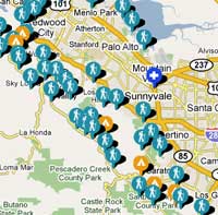
The site looks like it’d be especially helpful to folks in town for a few days, either on vacation, business or conferences. I did some poking around this morning to see how it works.
I ran Ryan’s Saturday hike through the link to Transit511.org, which showed exactly which combination of light-rail, bus, BART, and bus again to get me from North First Street in San Jose to the trail head along Highway 101 near Sausalito for the hike into the Marin Headlands. Great, don’t have to drive all that way. Not so great: 2.5 hours each way and $28.50 in fares for the round trip. By car, it’s about 110 miles round trip from San Jose, about $15 in gas at 20 mpg and $3 a gallon, and easily two fewer hours on the road. Normally a prime economic justification for taking transit is that you’d pay just as much to park anyway, but trail heads generally have free parking. (However: transit could get you to little-known trail heads in neighborhoods that have no parking).
Granted, this is an extreme illustration, given that I hardly ever venture up that way anyway. Also: transit passes would save a huge chunk of the fare cost — so anybody in San Francisco who already uses MUNI or BART can have all this nature goodness thrown in at no extra cost. Good on ’em.
511.org is full of helpful tips, though there can be absurdities: Transit and Trails points to Joseph D. Grant County Park — you know, 10 miles up into the hills on the way to Mount Hamilton. As sentient beings we know no buses go there, so 511.org helpfully suggests taking a cab the rest of the way. Sure. (Actually, road cyclists who love those twisty mountain roads would find this very handy because they can take their bikes on the bus — though I’m thinking they might be dubious of putting their $2,000 pride and joy on one of those exterior racks).
The site makes good use of geo-location features. You can enter your address, select a mileage range and see what’s out there. Dozens of practical routes have already been entered (for instance, buses would solve a lot of issues for backpacking on the Ohlone Wilderness Trail) Options are a bit thin in the South Bay, but folks in Marin or San Francisco have gobs more options. The site has a few oddities because the kinks are still being worked out, but it has tremendous potential. Soon folks will be able to share their own routes, which will widen options considerably.
Overall, I’d say add it to your bookmarks list.
Related links:
A wonderful resource! Tom, your example is tough to swallow – in those instances, where I want to get a bit farther afield, I go with CityCarShare or borrow a friend’s car. I sold the car four months ago, in a determined effort to downsize and reduce my carbon footprint, to see if I – a carbound nut – could go a year without the beast. So far, I haven’t looked back. We bike everywhere, use CCS or rent on longer extended excursions. Plus, I live close enough to Marin where it’s half that time and cost to get to that trailhead. (Now, getting to Hank Coe is a different kettle of fish, but I’d just haul butt down on CalTrans or BART and have Tom pick me up!)
There are a million ways to get by without a car and still get out and about to your favorite places…maybe just not as often, but then that just means more time spent exploring and adventuring nearer afield in your backyard paradise . . in my case, the Berkeley/Oakland hills.
You’re literally walking the walk!
As Ryan from the open space authority told me, there’s one more great thing about transit: No Bridge Tolls! He allowed that the options from the South Bay are more limited, but folks up your way — especially those who live in San Francisco, use transit all the time and are taking one-person trips to trailheads — really have no need to drive.
Plus you always meet interesting characters on the bus, right?
Just found your site. A few people in Michigan have been trying to put hikes together using public transportation. It’s a real challenge. There isn’t any in many places here.
Thanks Tom for posting and the wonderful review. We are working hard to add more features including the ability for folks to add their own trips, trailheads and features about those including photos. We are also working on getting trails in there as well. Register on the site and we’ll send you updates when new features are released or just keep coming back to check them out.
Enjoying the views and talking on your cell phone or reading a book on the ride to the trail is also a nice advantage to some of the stressful bay area driving.
Thanks again, Ryan