
I passed this park on my way home from Damascus, Va., a couple weeks back and immediately added it to the Must-Hike List. The Appalachian Trail passes through the upper reaches of Grayson Highlands and exerts a magnetic pull on just about anybody who shows up in the Massie Gap parking area. You get out of your car, gaze over a broad meadow with trail signs in the distance, and the next thing you know you’re trudging up to the AT.
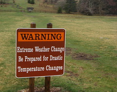 Bring your 10 Essentials — weather is crazy in the Highlands.
In classic Wrong-Way Mangan form, I was off the AT almost as soon as I was on it, but I’ll get back to that later. On a micro scale, Grayson Highlands is a handy gateway to the Mount Rogers National Recreation Area; on a macro scale, it’s a window on the entire Southern Appalachian region — terrain, flora & fauna, climate, rocky outcrops, expansive views.
What I noticed yesterday: Grayson Highlands’ status as a portal to nearby peaks causes many hikers to overlook trails within the park. Granted it was just one day in the off season, but I saw mobs of hikers in a half-hour on the Appalachian Trail, and hardly anybody in 4.5 hours on trails within Grayson Highland’s borders (this’ll change drastically in autumn leaf-peeping season, of course).
First thing you notice after driving into the park is it’s impossible to tell where the trails start without stopping the car and wandering around a bit. Easiest route is to park at the big Massie Gap lot, get out and start trolling for trail signs (they’re vertical and color coded to match the blazes of individual trails). I put in seven miles with about 1,200 feet of elevation gain, solidly in the “moderate” camp with only a few arduous stretches.
Two nice trails start out near the Massie Gap lot: the two-mile Cabin Creek loop, which passes a cool cascade of waterfalls; and the Pinnacle Peak Trail, which climbs 400 feet in four-tenths of a mile, topping out at the Big Pinnacle, which offers 50-mile views if it isn’t fogged in. It connects to the 1.8-mile Twin Pinnacles Trail, which has even more excellent overlooks.
I hiked all those, but only after I capitulated to the Animal Attraction of the AT. My brain is like any hiker’s, I suppose: I see signs saying “AT Ahead” and I figure that’s where I need to be. But seeing a dozen hikers in my first mile on the AT told me I needed to be somewhere else. Sometimes I hate this brain.
The sign warning of drastic weather changes did not exaggerate: I arrived to fogged-in peaks, gale-force winds and scant scant evidence of things improving. Two hours later there wasn’t a cloud in the sky, and the sun’s warmth was overwhelming the winds’ chill (the great thing about being ready for the worst is how happy you are when it doesn’t happen).
Time to let the pictures do some of the typing:
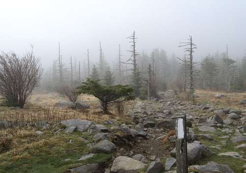
Here’s the trailhead at Massie Gap. Over my shoulder is the Rhododendron Trail, which connects with the Appalachian Trail after about a quarter-mile. Big Pinnacle is the summit of the peak in the background — I hoped the cloud cover would burn off so I waited to hike there last.
At last, an Appalachian Trail junction, where I can join the legions who’ve trod this dirt before me. Of course if you are not me you would see this sign just over to the left and notice the little sign below the big No Horses sign.
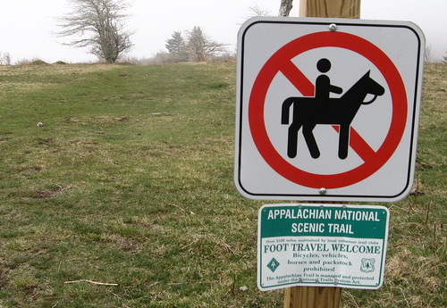
I took this picture 50 minutes later, which is when I confirmed that the gravel path to the left in the other picture is actually the Virginia Highlands Horse Trail. Fortunately it’s not so hard to get back to the AT after dodging horse-do for a half-mile. The trail leaves the park through an old gate; after that it’s a left turn and a short walk back to the AT.
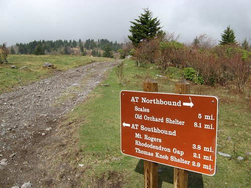
The main motivation for day-hiking this section of the AT is to stop in at Mount Rogers, the highest peak in Virginia. It’s an eight-mile out-and-back with excellent views of the mountains (though the peak itself is tree covered) on clear days. Trail signs for Mount Rogers hikers guided my way.
A trademark white blaze of the AT. Not far from here I realized I had actually driven two hours to explore the state park, so I turned back toward Grayson Highlands. As it turned out this would’ve been an excellent day for the Mount Rogers hike, but it was an excellent day to be hiking anywhere, once the fog cleared.
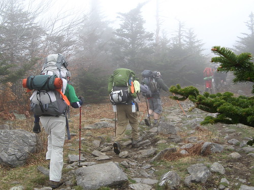
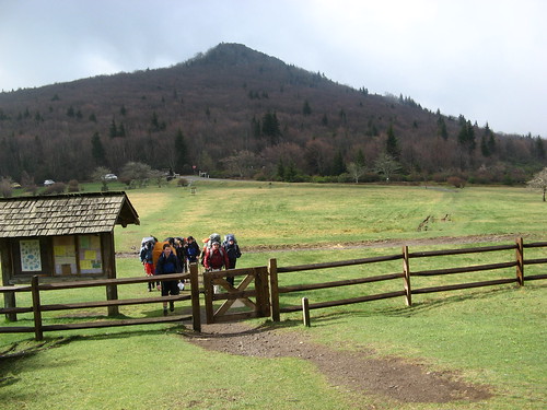
Backpackers slog up the AT.
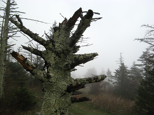
Gnarly stump near the border to Grayson Highlands.
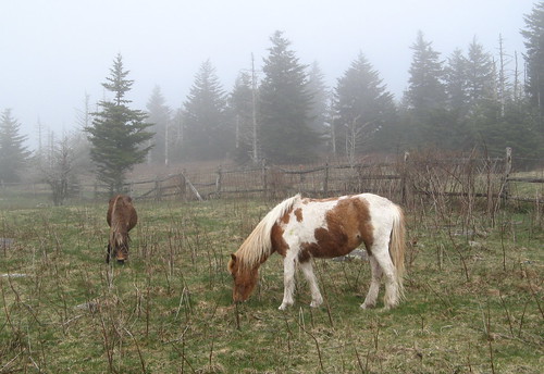
Required shot of Grayson Highlands’ resident ponies. From here it’s an easy downhill jaunt back to the Massie Gap parking area. I did the Cabin Creek Trail next, hoping the overcast skies would linger for another hour so I’d have a better chance at scoring some pretty waterfall shots. Sun came out about three minutes down the trail and stayed out the rest of the day. Too much light for photography, but otherwise wonderful.
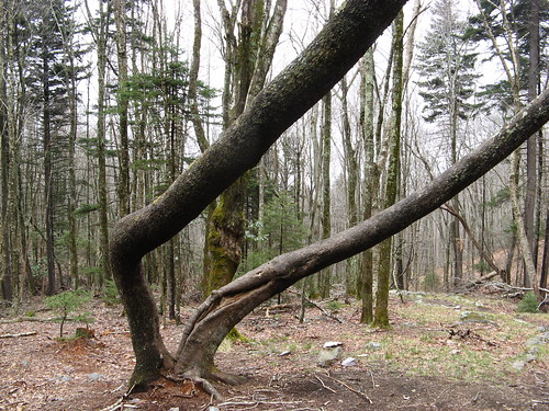
You know me, always on the lookout for misbehaving trees.
So here’s what happens on the Cabin Creek Trail: You enter a tree tunnel next to a small stream for less than a quarter mile. Then you hit a trail junction, where a right turn takes you to the waterfalls after a relatively short stroll, while a left turn requires about twice as much walking but promises a much more satisfying hike.
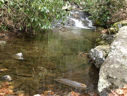
This is near the bottom of Cabin Creek, where the water burbling over rocks offers just a hint of what’s to come.
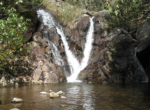
This gorgeous twin-flowing cascade is just up the trail. Basically you keep climbing and seeing more waterfalls the farther you go.
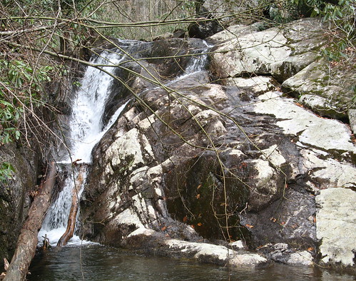
Another one on the way. Eventually you get to a sign pointing to a “waterfall overlook trail,” which offers plenty of opportunities to scramble up the creekside till you tire out and turn back.
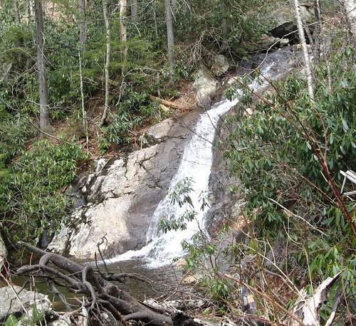
Last cascade I saw before turning back. I was tempted to see if I could bushwack my way back to a trail from here, figuring I could just break out my GPS and follow its track till I got back to someplace I’d hiked before. Then it occurred to me I might head up a hillside that was too steep to hike back on and end up in a predicament where all the choices are between bad and worse. Checking the terrain maps after I got home convinced me it’s basically insane to attempt a bushwack up and out of the Cabin Creek canyon.
One other note: vegetation blocks many of the views of the waterfalls, and just for fun it also obscures drop-offs in the footing as well. It’s real break-a-leg terrain if you’re not careful.
OK, one more destination to go: Big Pinnacle Trail. It’s mercifully short but precariously steep in a few places.

The view from Big Pinnacle is worth every step.

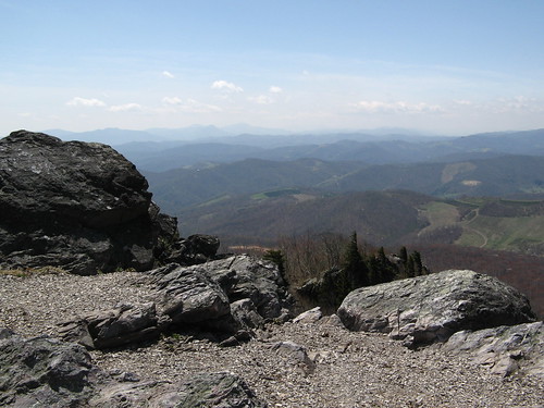
One more Big Pinnacle view, because one is never enough. After you’ve gaped in awe there for awhile, you can either go back the way you came or add an easy 1.8 miles on the Twin Pinnacles Trail. This was my route trail of the day before returning to the parking lot on the Big Pinnacle Trail.
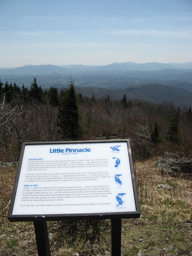
The view from Little Pinnacle (which is actually a few feet higher than Big Pinnacle) is wonderful too.
Parting thought: check the weather forecast before you come; if it’s one of those “partly cloudy days” with a sunny one expected tomorrow, it’s reasonable to expect the cloud cover to burn off in the afternoon. Hike in the woods in the fog before lunchtime, and hike the heights after the sun comes out.
Grayson Highlands links:
- Everytrail GPS tracks
- Virginia state parks page.
- Trail map (PDF download)
- Mount Rogers National Recreation Area
- Appalachian Trail interactive map
Google map of Saturday’s hike:
View Grayson Highlands State Park in a larger map
I’m glad you’ve checked out Grayson Highlands, a real gem for our part of the world. If possible, add to your must-do list to go back around the third week in June to Rhododendron Gap on the AT (about 6 miles RT). The rhodies display is absolutely amazing.
I definitely plan to check out the bloom … I was hesitant to rate Grayson Highlands as among the best in the Southern Appalachians because I figured there must be a lot more I haven’t seen that are just as good.
Having real mountains within a two-hour drive is pretty cool, I have to admit.
Tom,
Again, you’ve shown that not all beauty and adventure is found rest of the wockies!
Awesome views from big Pinnacle – after seeing some of your first few pictures I thought the fog might kill the views.
Excellent area for hiking. Super pictures and I Like your blog!
I really enjoyed your pictures. It brought back memories of a time when I was still in state highpointer mode (I think reality has caught up to me) and went after Mt. Rogers just about the same time of year. This would have been maybe 10 years ago. I have fond memories of the frosty forest and seeing the ponies through a chilly but beautiful mist. I was there on a weekday morning and saw absolutely no one that day. Not that I hate my fellow human beings, but sometimes those solitary experiences have a certain special quality.