
From the San Jose Mercury News, July 2007
There’s a tree-hugger born every minute at Big Basin Redwoods State Park.
The seductive charms of the park’s towering ancient redwoods become evident the minute you step on a trail. Before long these trees seem more like national treasures — the idea of chopping one down for lumber makes about as much sense as knocking down the Washington Monument for a highway bypass. Good luck working up the nerve to cut your own Christmas tree in December.
Acres: 18,000
Miles of trails: 80-plus
Hours: 6 a.m.-10 p.m. year-round.
Limitations: No dogs on trails (they’re OK in campgrounds if leashed). Camping only in designated sites; no open fires at backpacking camps.
Parking: $6 at the park headquarters; free at Waddell Beach.
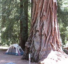
Camping: $25 per night; reserve a site at www.reserveamerica.com; don’t wait, they go quickly.
Backpacking: $5 per night. Reserve a site by calling (831) 338-8860 weekdays, 10 a.m.-5 p.m. These fill up several weeks in advance.
Driving directions: Take Highway 17 south to Mount Hermon Road. Stay on this road as it goes through the city of Scotts Valley. Mount Hermon Road ends at an intersection with Graham Hill Road. Turn right. You will immediately come to another lighted intersection (Highway 9). Turn right again. Take California Highway 9 to Boulder Creek and head west on Highway 236 for nine miles to the park entrance; continue to park headquarters. A shorter route takes Highway 9 from Saratoga to the north end of Highway 236, but this segment of Big Basin Way is much narrower, with more curves.
On the Web: www.bigbasin.org
Best Bay Area hikes
Best California hikes
Big Basin, in the Santa Cruz Mountains southwest of San Jose, is California’s oldest state park, and one of its best. Trails are generally well-marked and maintained. The park’s popularity draws crowds on the weekends, but most hikers congregate on the busy Skyline-to-the-Sea and Redwood trails. Other routes in the park often are lightly traveled but equally rewarding.
Standard precautions: Get a map ($3 at the park headquarters) — even with one, you’ll probably get turned around once or twice. Poison oak is common along narrow trails. Give yourself plenty of time to return before sunset. Water in the park’s streams must be purified before drinking.
Hike suggestions
Easy: Don’t miss Mother and Father of the Forest — the tallest and fattest redwoods at Big Basin — along the flat, 0.6-mile Redwood Trail. Or take the Skyline-to-the-Sea trail north for a couple of miles to the Maddock Cabin site for a lesson on frontier living, where a mom’s prime concerns were her kids getting an education and not getting eaten by grizzly bears (the cabin’s long gone but an interpretive board tells the Maddock family’s story).
Moderate: The Pine Mountain Trail behind the Blooms Creek Campground is an occasionally rugged 1,100-foot climb over two miles to a stony overlook called Buzzard’s Roost, which promises amazing vistas in every direction. Footing is dicey in places; be extra careful on wet stone.
Hard: The signature hike at Big Basin is the 12-mile Berry Creek Falls Loop from the park headquarters via the Skyline-to-the-Sea and Sunset trails. Give yourself five or six hours, and be ready for an amazing trek though the ancient redwoods. The route up from Waddell Beach on the Pacific Ocean north of Santa Cruz is less redwood-intensive, but has a far gentler grade.