
From the San Jose Mercury News, August 2007
Some hiker friends of mine visit Butano State Park mainly as excuse to stop off for pie at Duartes in Pescadero, a few miles down the road. Duartes bakes luscious pies with berries picked from nearby fields, and any excuse to stop in for a slice is valid.
Get the best map
Acres: 3,500-plus
Miles of trails: 30-plus
Limitations: No dogs on trails. No bikes or horses on single-track trails.
Parking: $6
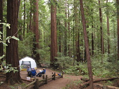
Camping: 21 drive-in and 18 walk-in campsites; $25 per night; reserve at www.reserveamerica.com. Trail camp, 5.5 miles from park headquarters, has seven sites available first-come, first-serve; $10 per night — pack your own water, there’s none at the campsite.
Driving directions: From San Jose, take Highway 92 west to Half Moon Bay and head south on Highway 1 for 15 miles. Turn left on Pescadero Creek Road, go 2.5 miles to Cloverdale Road, turn right and go 4.3 miles to the park entrance. For more routes, search on “Butano State Park” at maps.google.com
On the Web: www.parks.ca.gov
But Butano is worth a visit regardless of your pie-craving proclivities. The park has remarkable biological diversity — six distinct habitats — and an excellent mix of trails: flat walks along shady creeks, rocky hillside passages, hill climbs steep enough to require stairs.
From mushrooms and banana slugs on the forest floor to scrub jays and redwoods far above, Butano is a feast for the amateur naturalist (professionals’ mileage may differ, though; going there may feel too much like work).
And the more miles you hike, the more pie you can consume with a clear conscience.
Standard precautions: Poison Oak is plentiful. Mileage estimates are listed on the park map (50 cents at the entrance kiosk), but not on most trail markers. Dress in layers: it can be cold in the morning and balmy in the afternoon. Parking is limited at the main entrance, but there’s more along the road into the park.
Hike suggestions:
Easy: The one-mile Six Bridges Trail shows off the park’s biodiversity. At one end, it’s alder woodland with thick, enclosing greenery. At the other it’s towering second-growth redwood — mostly flat with a few reasonable climbs along the way.
Moderate: The 1.6-mile Doe Ridge Trail in the center of the park gently ascends the canyon through a gorgeous stand of redwoods up to the Olmo Fire Road. No matter how you get there, hiking all of Doe Ridge will provide four to six shady miles though the park’s varied forests.
Hard: For around 11 miles of arduous-but-rewarding trekking, take the Jackson Flats and Canyon trails to the backcountry campground, then head back via the Olmo Fire Road and Ano Nuevo Trail (this is very steep; if your knees hate down-hills, consider starting on Ano Nuevo and reversing this route).
Glad to have found your write-up! I am hiking the ‘hard’ hike with my Tuesday group of Sierra Clubbers. These guys are in their 60’s on up and can hike the hell outta any trail. They almost always hike over 10 miles with plenty of elevation climb. I also didn’t know that Duarte’s had great pie. I did, however, have the tacos at the gas station. Have you seen the metal skeleton with the 50 caliber weapon off of Stage Road? Totally bizarre.
They’ll give you a good march at Butano … it starts at sea level and goes straight up to the ridges in a couple places.
I need to get back there, it’s a great park.