
From the San Jose Mercury News, June 2008
Don’t let the hubbub scare you away from Huddart.
Acres: 973
Miles of trails: 24-plus
Hours: 8 a.m.-8 p.m. April-August
Parking: $5; follow signs to Zwierlein Trail Heads parking area
Limitations: No dogs or other pets
Driving directions: From Interstate 280 in San Mateo County, take the Woodside Road exit (California Highway 84). Go west through town of Woodside for about 1.5 miles, then go right on Kings Mountain Road. Go about 2 miles to the park entrance on the right.
On the Web: www.parksupport.org
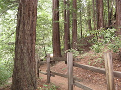
Huddart County Park, built on a Santa Cruz Mountains hillside west of Woodside, is better known for family reunions and Fourth of July barbecues than hikes. The racket of car engines and rowdy kids takes it off many veterans’ must-see lists, but the main gripe about Huddart dissolves within minutes of venturing into the woods beyond the party zone.
The farther you go, the more likely you’ll have a vibrant forest of redwood, oak and madrone mostly to yourself (you might have to share with a few joggers and equestrians). A stroll to the neighboring Phleger Estate promises one of the nicer redwood hikes on the Peninsula.
Standard public park amenities – ample parking, well-marked, sanely graded trails and running water (real toilets!) at the trail head – make Huddart a good choice for beginners. Seasoned hikers may scoff at such luxuries, but they’ll be scoffing somewhere else, leaving more room on the trails for the rest of us.
Standard precautions: Watch for poison oak on narrow trails, and horse poop on all of them. Dress in layers – it can be much cooler than you expect at the beginning, but the park is on a hillside with lots of climbing, so you can heat up quickly.
Hike suggestions
Easy: From the Zwierlein Trail Head, try an out-and-back on the Crystal Springs Trail. The park’s noise will be out of earshot in minutes. Turn back in 20 minutes to a half-hour for a couple of pleasant miles of hiking.
Moderate: Skyline Boulevard is 3.6 miles from the Zwierlein area: a vigorous hike via Crystal Springs, Dean and Chinquapin trails gets you up there. Take Summit Springs Trail to Crystal Springs, and stay on it all the way back for seven shady miles that sample all the park’s biodiversity.
Hard: From Zwierlein, take Crystal Springs Trail to the neighboring Phleger Estate, and fashion a loop up to Skyline Boulevard via the Miramontes, Raymundo and Lonely trails, returning on Mount Redondo Trail and retracing your route back to the parking lot. Expect about 10 miles of excellent redwood hiking.